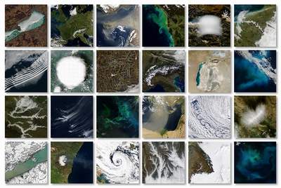
Satellite based remote sensing includes the space-based observations both of the surface and the atmosphere, measured by passive or active techniques.
Remote sensing of the terrestrial vegetation by passive methods is based on the space-borne measurements of the sunlight reflected by the surface.
The reflection, absorbtion, and transmission of the sunlight by the vegetation depends on the spectral wavelength, and the state, productivity and structure of the vegetation.
Combining the measurements of the different spectral channels vegetation indices can be derived, which are apropriate to gain information for the
state, productivity and phenological cycle of the vegetation.
Changes in the state of the vegetation can be due to the phenology itself, but it can be also
caused by other processes, like the effects of weather and other abiotic factors, or other natural or anthropogenic factors. Due to the global coverage
and the high spatial and temporal resolution of the data provided by satellites, the remote sensing is an unique and excellent tool to study the
terrestial vegetation and its changes.
Our research covers:
- investigations of the effect of weather (as abiotic factors) and biotic factors on vegetation,
- crop yield estimation and forecasting of agricultural plants,
due to the fact that monitoring the vegetation can be used not only for the detection of changes in the state of the vegetation, but also to determine its
productivity and crop yields,
- radar based investigations, since the vegetation can be observed and described by activ remote sensing techniques as well,
which is based on the detection of the returning signal of the emmited electromgnetic waves.
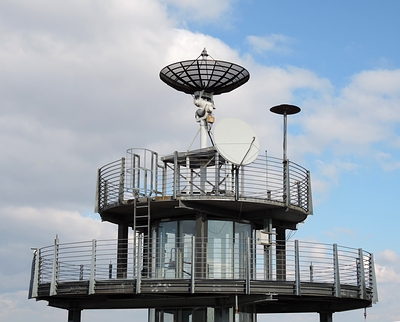
Data received by the direct broadcast receiving station operated by the Space Research Group
(and located at the top of one of the buildings of the Eötvös Loránd University) provides possibility for real-time observations of the surface and the atmosphere.
The main received data of meteorological and environmental satellites (both LEO and GEO) are the MODIS, NOAA AVHRR and ATOVS, and SEVIRI data.
For more information see...
Remote sensing of the terrestrial vegetation