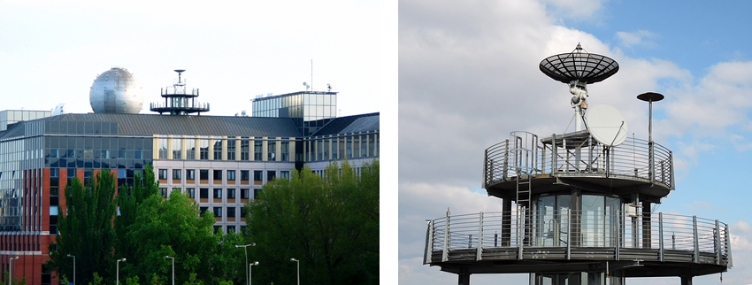
The Direct Broadcast receiving station was established by the Space Research Group at the top of the so-called Northern
building of the Eötvös Loránd University at Lágymányos, in Budapest, in 2002 (47,475N, 19,062E, 40m AMSL).
At the beginning, the station was capable to receive data only broadcasted by meteorological satellites
(NOAA HRPT, FengYun CHRPT) with coarse (1 km) spatial resolution. In September, 2004 the station was significantly
upgraded by the support of the Hungarian Space Office and the Ministry of Informatics and Telecommunication,
including a larger antenna and stronger electronics. Thanks to these improvements the station is able to receive the fine (250 m)
resolution data of the MODIS sensor onboard satellite EOS-AM1 (Terra) and EOS-PM1 (Aqua). Besides the data of the
conventional polar orbiting remote sensing satellites, data broadcast from space weather satellites (such as Chibis and Relec)
is also possible, which are performing important observations about the electromagnetic state of the upper atmosphere and the
plasmasphere. Thanks to the further developments in 2006, another antenna was also installed receiving data of geostationary satellites (Meteosat-11) as well.

The Direct Broadcast antenna is receiving the radio signal of the tracked satellites in real time.
These radio signals are converted into digital signals by the central processing unit.
Due to this, we are able to get data about those regions which are observed during the real time data transmission,
i.e. when the given satellites are above the horizon of receiving station (Budapest). This means that the area of the acquisition covers
the whole Europe, and some parts from Asia, Africa, and the Atlantic-Ocean. The image below shows the approximate area of the acquisition.
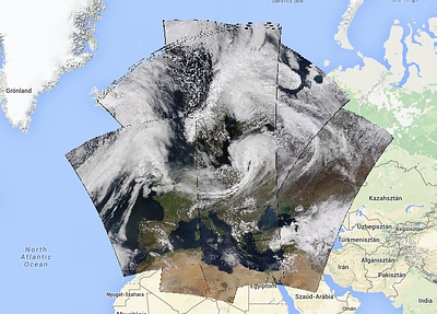
Overlapping MODIS overpasses on one day
Station specifications:
- Quorum head and motor, Datatools Product antenna, and Kongsberg Spacetech data-acquisition software
- L band: 1680-1710 MHz
- S-band: 2.2-2.4 GHz
- X-band: 7.8-8.42 GHz
Received polar orbiting data:
- Terra/Aqua MODIS
- NOAA HRPT (AVHRR3 + ATOVS)
- FengYun CHRPT
- Chibis and Relec (for the measuremnets of the electromagnetic waves of the plasmasphere)
Received geostationary data:
- MSG (Meteosat-11) SEVIRI
Real-time data processing:
Data received by the station provides possibility to study and monitor in near-real-time the surface and atmosphere of the Earth.
For more details see (in Hungarian):
Közvetlen vételű MODIS adatok alkalmazásai Magyarország térségére.
Automatic processing of the received MODIS data is based on our processing chain consisting from more steps,
producing several products both for the surface and the atmosphere from the raw received data.
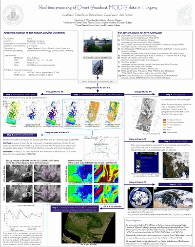
Real-time processing of MODIS data
From the received MODIS data a MODIS image gallery was also created,
where the true color images are presenting many interesting and spectacular phenomena since 2004.
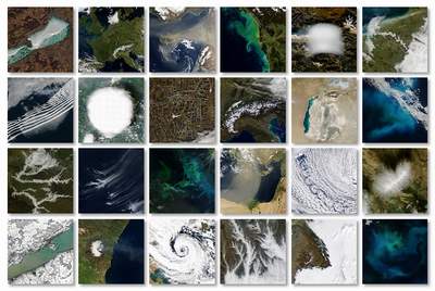
Example images of the MODIS gallery
The received data are used to researches (e.g. Bognár et al., 2017;
Kern et al., 2008), in what students are involved as well.
Related articles, papers (in English and Hungarian):
- Bognár et al., 2017: Yield estimation and forecasting for winter wheat in Hungary using time series of MODIS data (Int. J. of Rem. Sens.)
- Koma et al., 2017: A Balaton klorofill-a eloszlásának monitorozása MODIS-adatok alapján (Geodézia és Kartográfia)
- Kern et al., 2014: Közvetlen vételű MODIS adatok alkalmazásai Magyarország térségére (RS&GIS)
- Kern, 2014: A vegetáció megfigyelése az űrből (Természet Világa)
- Kern et al., 2008: Estimation of vertically integrated water vapor in Hungary using MODIS imagery (Adv. Space. Res.)
- Timár és Kern, 2007:
Sivatagi porcsóvák és porjelenségek a Földközi-tenger felett - Űrfelvételek az ELTE műholdvevő állomásról (Földrajzi Közlemények)
- Timár et al., 2006:
MODIS-adatvétel az ELTE műholdvevő-állomásán (Geodézia és Kartográfia)
Related MSc and PhD theses (in Hungarian):
- Koma Zsófia, 2015, MSc, A Balaton klorofill-a eloszlásának folyamatos monitorozása MODIS adatok alapján
- Kern Anikó, 2011, PhD, NDVI vegetációs index előállítása távérzékelt AVHRR és MODIS adatok alapján
- Gelybó Györgyi, 2006, MSc, A légkör vertikális szondázása a NOAA műholdak ATOVS mérései alapján
- Juhász Henriett, 2006, MSc, Tengerfelszín hőmérséklet becslése NOAA AVHRR adatok felhasználásával
- Kern Anikó, 2004, MSc, NOAA AVHRR/3 műholdképek vétele, előfeldolgozása és minőségbiztosítása (ELTE TTK HRPT vevőállomás)
- Quorum head and motor, Datatools Product antenna, and Kongsberg Spacetech data-acquisition software
- L band: 1680-1710 MHz
- S-band: 2.2-2.4 GHz
- X-band: 7.8-8.42 GHz
- Terra/Aqua MODIS
- NOAA HRPT (AVHRR3 + ATOVS)
- FengYun CHRPT
- Chibis and Relec (for the measuremnets of the electromagnetic waves of the plasmasphere)
- MSG (Meteosat-11) SEVIRI
Data received by the station provides possibility to study and monitor in near-real-time the surface and atmosphere of the Earth. For more details see (in Hungarian): Közvetlen vételű MODIS adatok alkalmazásai Magyarország térségére. Automatic processing of the received MODIS data is based on our processing chain consisting from more steps, producing several products both for the surface and the atmosphere from the raw received data.

- Koma et al., 2017: A Balaton klorofill-a eloszlásának monitorozása MODIS-adatok alapján (Geodézia és Kartográfia)
- Kern et al., 2014: Közvetlen vételű MODIS adatok alkalmazásai Magyarország térségére (RS&GIS)
- Kern, 2014: A vegetáció megfigyelése az űrből (Természet Világa)
- Kern et al., 2008: Estimation of vertically integrated water vapor in Hungary using MODIS imagery (Adv. Space. Res.)
- Timár és Kern, 2007: Sivatagi porcsóvák és porjelenségek a Földközi-tenger felett - Űrfelvételek az ELTE műholdvevő állomásról (Földrajzi Közlemények)
- Timár et al., 2006: MODIS-adatvétel az ELTE műholdvevő-állomásán (Geodézia és Kartográfia)
- Kern Anikó, 2011, PhD, NDVI vegetációs index előállítása távérzékelt AVHRR és MODIS adatok alapján
- Gelybó Györgyi, 2006, MSc, A légkör vertikális szondázása a NOAA műholdak ATOVS mérései alapján
- Juhász Henriett, 2006, MSc, Tengerfelszín hőmérséklet becslése NOAA AVHRR adatok felhasználásával
- Kern Anikó, 2004, MSc, NOAA AVHRR/3 műholdképek vétele, előfeldolgozása és minőségbiztosítása (ELTE TTK HRPT vevőállomás)