Vlf wave propagation
Satellite remote sensing
Sun-Earth Physical relations
Geoinformatics
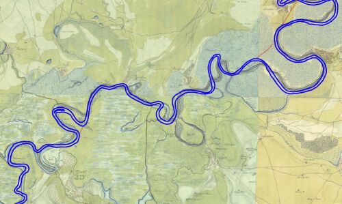
River dynamics
Our research group has dealt with analyses in river dynamics since 1997,
mostly with the investigation of the alluvial sections of the Tisza River
and its tributaries. In the framework of this study, using the map sections
of the second military survey of the Habsburg Empire (sections dated between 1850-1860),
the digital database of the ancient river course, between the cities of Tokaj and Szeged,
has been developped. For some parts of this section, using the sections of the first
military survey of 1783-1786, this older course has been digitized and fit to modern
projections as well (see the image below). During this 70-80 years between the two
survey, the river course has been obviously changed without any human impact.
Analyzing this river course database, the present-time tectonic activity
of the Mid-Hungarian Shear Zone (crossing of the Tisza River between the villages of T
iszavárkony and Vezseny, south of the city of Szolnok) has been verified.
To complete and support of the analyses in the river dynamics, the development
of the high resolution digital elevation models of the Tisza floodplain has been started
as well. Combining these models with the shallow borecore interpretation studies,
led by Pál Sümegi (University of Szeged), it is possible to draw the
Late Pleistocene-Holocene development history of the floodplain. Moreover,
the elevation models act as a physical geographic base of archeological studies, too.
Cooperations:
 Dept. of Quaternary Geology and Geomorphology, Vrije Universiteit, Amsterdam, the Netherlands
Tisza River Project
University of Szeged, Dept. of Geology and Palaeontology, Hungary
Mid-Tisza Region Water Authority, Szolnok, Hungary
Hidrometra Hydraulic Engineering Ltd., Budapest, Hungary
Nagykörű Landscape Rehabilitation Program, Nagykörű, Hungary